


Col de la Croix Chabaud

maupassant38
User
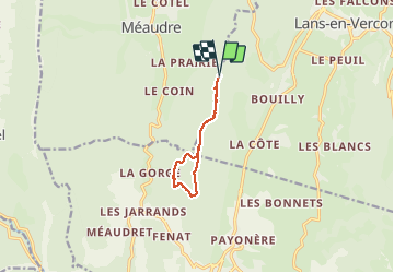

Length
8 km

Max alt
1373 m

Uphill gradient
234 m
Km-Effort
11.1 km

Min alt
1218 m

Downhill gradient
234 m
Boucle
Yes
Creation date :
2019-09-03 08:47:15.991
Updated on :
2019-09-03 13:03:20.616
2h01
Difficulty : Easy

FREE GPS app for hiking
 SityTrail
IGN / Geographical institutes
SityTrail Plus
The world is yours!
About
Trail Walking of 8 km to be discovered at Auvergne-Rhône-Alpes, Isère, Autrans-Méaudre en Vercors. This trail is proposed by maupassant38.
Positioning
Country:
France
Region :
Auvergne-Rhône-Alpes
Department/Province :
Isère
Municipality :
Autrans-Méaudre en Vercors
Location:
Méaudre
Start:(Dec)
Start:(UTM)
700464 ; 4998978 (31T) N.
Comments